HISTORY OF RIVER HILLS PLANTATION

By Wil Couch
A complete set of the Sea Pines Plantation newsletters and the River Hills Press have been collected and bound. These and many other documents and pictures of the early days of the Plantation are available at the River Hills Community Association offices for those of you who may have a continuing interest.
1701
First recorded description of the area and its population
1738
Catawba lost half their population to a smallpox epidemic.
17??
Aaron Wood’s house built on what is now Five Oaks Lane
1750
Beginning of Scotch-Irish invasion
1755
Catawba scouted for British during French and Indian War
1759
Second smallpox epidemic took half only a total of 400 demoralized survivors.
1761
Thomas Spratt adopted as Kanawaha given 3,000 acres by Catawbas
1762
Treaty of Augusta created reservation of 180 square miles (115,000 acres)
1763
King Haiglar murdered by a Shawnee war party
1772
York County, North Carolina becomes York County, South Carolina
1778
General Cornwallis chased south from 'Hornets nest'
1780
Battle of Kings Mountain
1785
The Constitution of the United States of America signed
1829
Andrew Jackson Inaugurated
1850
Mrs. Jamie Boyd’s log cabin built near Duck Hook Circle
1887
Harper home built (on hill - across 49 from back gate)
1905
Catawba Power Company dam created a lake of 5,000 acres
1918
World War I ended
1923
-Calvin Coolidge sworn in
- First Buster Boyd bridge opened
1926
Duke Power raises the dam expanding the lake to 12,455 acres
1927
Joe Jones built his Fish Camp
1929
Stock Market Crash - 89% of value lost
1933
FDR chats by the fire
1938
-Dr. Robert Moore purchased tract - built marina - planted apple orchard
- Reforestation of depleted cotton fields with long needle pines
1945
- FDR dies - Harry Truman takes office
- End of WWII
1948
Curtis Johnson purchased Commodore Point and Camp Thunderbird area.
1950
Belk purchased Commodore Point for summer home and employee recreation
1953
Ike takes over the country (Eisenhower that is)
1957
Wilson Lewith and Maurice Weinstein purchase for Commodore Yacht Club
1961
- JFK -- 'Ask not what your country can do for you ...'
- October - Second Buster Boyd bridge opened to traffic
1967
Lewith et al launched plans for Golf/Residential development
1969
- Richard Nixon is president
- Commodore Golf Club opens for play
1970
- Charles Fraser, Sea Pines Development of Hilton Head, buys out Lewith group
- October -
Tom Carr’s 80 Fairway Ridge first lot sold ... 49 others by December
1971
- Pro shop and sales center plans approved
- Virginia & Bill Smith start construction of first house
- Commodore Yacht Club slips closed
- Water / Sewage system started
- First reworked nine golf holes ready for play
- Bobby & Kermene Yon first to move in
1972
- June 10 -
River Club grand opening cocktail party - Greenhouse constructed
- Marina plans announced ... Yacht Club organized
- Carowinds opens
- State Road
#154(Hamilton’s Ferry) privatized
1973
- January -
Southern Bell starts extended telephone service (local to Charlotte)
- Stock Market begins 2 yr Bear Market ... looses 45% of value
- June -
Moore’s Landing (Marina) Grand Opening -- 700 people, 300# shrimp
- Marina, Tennis courts, General Store, Bridge Bar, Wreck Room
- November - First Villa sale closed by Mr. and Mrs. Hugh Miller of Mexico
1974
- April -
River Club offered for sale to members
- May -
Bluff Villa swimming pool opened
- June -
Duke begins Catawba Nuclear Station
- September - Ford Motors 1975 models taped here distributed dealers nationwid
1975
- March -
River Hills Community Association activated
-April -
River Hills Press launched
- May -
River Hills Press began publication
- May - Community Church hires Gene Jester
1977
-Jimmy Carter installed
-Membership buys the River Club ... River Hills Country Club incorporate
-Club parlor converted to the main dining room new kitchen built
-Community Center building dedicated for church and community functions
-Sea Pines sells water/sewer system to Utilities Inc.
-Community Association assumed ownership of the streets
1978
- River Hills Marina Club incorporated and marina complex purchased
-Emergency Squad incorporated
-Tennis pavilion converted to pro-shop for tennis togs and equipment.
1979
- All roads and common property deeded to River Hills Community Association
- Golf Pro Shop and the Bag Room moved to the old sales office
- The Landings (Shipmaster and Quayside) developed as patio homes
1980
- Commodore Point traded with Camp Thunderbird
- The River Hills Emergency Squad commenced operation
- Lake Wylie Chamber of Commerce founded
1981
- The Reagan Years begi
-Moore Villas, near the Marina, were annexed
-Mortgage rates peak at about 16%
-Lake Wylie Plaza -- Harris-Teeter, JacLyn’s, Old World Deli -- open
-Harry’s hardware opened
-Bank of Fort Mill opened (NationsBank) at the Plaza
-T V cable installed
-Back gate house rejected
1982
- Lake Wylie Woods construction started
- John Wilkerson(R) vs. John Spratt(D) for congress
- Back gate house rejected again
1983
- Lake Wylie Athletic Club opens
-Plantation Square shopping opens
-Plantation office condos available
-RHCA propose administration building at Heritage and Honeysuckle
1984
- Catawba Nuclear begins test
- RH Genealogist formed
1985
- Front Gate Guard House tripled in size
-Mortgage rates fall below 10% first time since 1978
-Commodore Utilities proposes a 37% increase in water rates
-Olympic pool opens at the Club
1986
-Cemetery donated by Erwin \ Spratt
-Church sanctuary expansion begun
-Library campaign begun
-Harris-Teeter adds deli-bakery
-Waterside - Food Lion Opens
Administration building approved at ball field location
1987
-Lake Wylie Branch library approved by York County Library Board
-RHCA Administration Building ribbon cutting - June
-Hull-Ryde room addition to the library announced
-Dow loses 34% in ten days
1988
-Four Lanes announced for Route 49
Dairy Queen Opens
1989
- Bush takes over
-Library opens - April 29
-General Store converted to RH Conference Center
-Acquisition of Stable area from Mark Erwin denied only 64.5% approval
-Hugo attacks -- September 22 3:00am
-Sewer system enlargement permit denied
1990
- Hinson Plant Clean-up
-Zip code denied
-Barry Henfey manages the RHCC
-Iraq ivades Kuwait - Market drops 21.2%
1991
-Roy Atwell administers RHCA
-Natural Gas cometh
- Chief Joe Smart takes command of RHCA security
1992
-'Save the Stables' campaign 83.76% in favor
-CWS & County sign water / sewer contract
1993
- 'President' Clinton said: 'its the economy stupid.'
Contracts for widening Route 49 = $5.8m
1994
-The Walkpath proposed (defeated)
Overlay sign ordinance approved
1995
- New Front Gate Sign and fence (money from land sale for widening Route 49)
1996
End of another Era -- River Hills Press ceases publication
1997
- Association approves capital expense fund dues increase
-Mortgage rates under 7%
1998
Marina Picnic Pavilion opens with over 200 members & guests
PRE COLONIAL TIMES: DEEP BACKGROUND
On March 24, 1663, Charles II granted to the Lords Proprietors a slice of North America running from the Atlantic to the Pacific, lying between 36 degrees north latitude on the north and 31 degrees on the south. This huge section of the continent was granted absolutely to the following men, to be financed by them, and for them to profit from, and to rule, with the help or interference of such a local government as they might permit. Only the King was above them. In the order named in Charles' charter they were: the Earl of Clarendon, the Duke of Albemarle, Lord Craven, Lord Berkeley, Lord Ashley, Sir George Carteret, Sir William Berkeley and Sir John Colleton. Names which continue in the lexicon of cities and counties of the Carolinas.
The British Crown commissioned John Lawson, a young Englishman, as the first Surveyor General of the Carolinas. In 1701 while surveying in the Waxhaw area he contacted a Siouan-speaking aborigine tribe. These natives called themselves Iyeye (people) or Nieye (real people). These are the people that have become known as the Catawba Indians. There is a tradition in the tribe that they originally came from the north, (perhaps the upper Ohio Valley, but even Canada has been suggested), driven south by the Seneca at the beginning of the Beaver Wars.
Some contend that Catawba is an Indian word meaning: divided or separated, which further supports the migration legend. By this theory, they are supposed to have arrived in the Carolinas about 1650. Their unique language and enduring hostility with the Cherokee tends to support this theory, also some Catawba cultural traits, most notably the forehead flattening of male infants, argues for a long time residence south of the Ohio River. Still other sources state that Catawba means 'river people,' and only came into common use in the Carolinas after its introduction by the white man about 1715. In any event, they were definitely established along the Catawba River in the area now known as York County in 1650.
THE AREA
The land between the Catawba and the Broad River was a prairie. A hunter’s paradise foraged by both the Catawba on the east and the Cherokee to the west. It was the cause of many skirmishes between the two groups. One story contends that many years before the Englishmen came, a battle was fought at the Nation Ford. 1100 Cherokees and 1000 Catawbas braves where killed in a single day. This battle brought about a treaty between the tribes that ended their bloody wars and declared all the land between the Catawba and Broad Rivers would remain unoccupied and would be peaceably available to both tribes for hunting and fishing. Large areas were cleared by the Indians to improve the grazing by vast herds of deer, elk, and buffalo that pastured there.
The Catawba flourished in this era numbering as many as 10,000 when first recorded by Lawson. These numbers, however, declined rapidly during the next 70 years due to a combination of the white man’s diseases to which they had no immunity, and to addiction to the alcohol brought by the white trappers and traders. Hence when the first British estimates were made in 1728 they had only 400 warriors and a total population of about 1,400. They lost half of these to an epidemic of smallpox, during 1738.
The Catawba were friendly and supportive of the British from the beginning Their alliance with the British army continued into the first years of the French and Indian War (1755-63), but a second smallpox epidemic (1759-1760) took half of their remaining tribe leaving a total of less than 350 survivors. With only 60 warriors, the Catawba volunteered to serve the British as scouts during the Cherokee War (1760-61), but this was their last important contribution. The South Carolina State census of 1826 found only 110 Catawba.
THE
RESERVATION
CAROLINA VILLAGE 1585

The Catawba had always been tolerant of British settlers, but in the 1750s when large numbers of Scotch-Irish Presbyterians moved in from Pennsylvania the tribe became disturbed and requested the government set aside land for its exclusive use. Through the Treaty of Pine Hill (1760) and the Treaty of Augusta (1762) created a reservation in eastern York County. It consisted of 180 square miles (115,000 acres) along the Catawba River to this extent the proprietors acknowledged the tribe’s service to the state and to the Crown. It is difficult to think of another Native American group for which a state established a reservation so their people could stay.
INDIAN GIVERS
From the beginning, however, the Catawba reservation suffered from encroachment by white colonists. Between 1761 and 1765, many whites simply moved in ignoring the reservation’s boundaries. South Carolina answered a 1763 Catawba protest with a promise to evict the trespassers, but nothing was ever done. The South Carolina government was unwilling to move against its white citizens.
By 1826 whites had settled virtually all of the reservation lands. South Carolina allowed the Catawba to exercise rights over their reservation even when the Cherokee where being forced out of South Carolina in the 1830'Parade of Tears' to a reservation in Oklahoma But the Catawba land base continued to shrink. In 1840, at the Treaty of Indian Ford, the Catawba sold most of their land rights to South Carolina. This state treaty was probably a violation of federal law at that time. In any event all that remained of the once great Catawba Nation was 600 acres of their old reservation and 110 poverty-stricken dispirited tribal members.
KING HAIGLER
The chief of the Catawba during much of this time was known as King Haigler, the tribal leaders having assumed titles of their European royal ‘counterparts.’ Even in those days King Haigler was a bit eccentric by white-man’s standards, but he was always friendly to the English and tried hard to impress them with his loyalty. One incident recorded in Dr. Maurice Moore’s Reminiscences of York County illustrates the friendship and respect the Catawba and the early settlers held for each other. Dr. Moore relates that a French dancing master was touring the area. He performed for a group of Catawba in exchange for some food and a night’s shelter. As part of his performance, the Frenchman played a fiddle. One of the Catawba braves was so intrigued with this instrument he quietly followed the Frenchman from the fort and later ambushed and killed the dance master in order to steal the fiddle.
The early white settlers, concerned that if this crime went unpunished, other braves might consider it a sign of weakness and a license to treat the white-man and his property with impunity. They went to the Catawba camp and expressed their deep concerns to King Haigler. The King was very disturbed over this breach of friendship. He rose to his feet and summoned all of his braves before him. When they were assembled, he raised his rifle, took careful aim, shot and killed one of the braves. There was no trial, no questions, before or after the shooting. It was strange justice, but effective.
King Haigler has been described as the ultimate politician. Knowing that he could not hold the Fifty-five million acres that the Catawba nation originally claimed as theirs, he negotiated a deal with the invading land-hungry Europeans. A deal that everyone thought would accommodate the Europeans and still protect the Catawba people. He settled for two million acres, which the British Proprietors agreed to respect.
One of the earliest settlers in the area was Mr. Thomas Spratt. He made friends with the Catawbas and was so well liked by them that he was adopted and given the Catawba name of Kanawha. He was given five square miles (3,000 acres) of land within the reservation. At Mr. Spratt’s request, the natives also gave two thousand acres to his friend, William Ervin. The two pioneers settled on this land and while Spratt successfully farmed his land and continued his relations with the natives, William Ervin proceeded to successively lose three herds of cattle to distemper. He became so disgusted that he traded all of his land for an Indian pony, a silver watch, and an old wagon. He moved his family down to Yorksville (now York). Some of his descendants later moved on to Morganton, NC. It is likely that former U.S. Senator Sam Ervin, who played a prominent role in the Nixon Watergate hearings, was a direct descendant of William.

END
OF AN
ERA
-King Haigler Chase in River Hills is named after this Indian leader, and Newriver Trace is named for his niece, Sally Newriver.
-This statement has been debated stating that she was older at the time of the time of the Generals death.
As the French and Indian war neared its end in 1763 King Haigler¹ was killed by a Shawnee war party. His assassination is generally regarded as the end of the Catawba power in the region. He died without an heir leaving the Catawba without a leader. He was thus the last King of the Catawba. Only one sister remained of the Catawba royalty. She married General New River who had taken the British military title during the ‘War of the Insurrection' or the ‘Revolution’ as the ‘Colonist’ called it.
Both General New River and his wife died soon after the King, leaving their five-year-old daughter, Sally, an orphan. Thomas Spratt² took this little princess into his home and reared and educated her with the same advantages as he provided his own daughter. Sally Newriver never married. The smallpox epidemic had left her the sole scion of the Catawba royalty and she could not marry beneath her station. Revered by the other members of the tribe, loved by the Caucasians, she lived to a ripe old age, as a right noble individual, a worthy representative of the tribe’s royalty, which passed with her into the grave.
RE-BIRTH OF A NATION
Although recognized early by the state of South Carolina, the Catawba nation never received any recognition from the United States of America until 1941 when their existence was acknowledged. In 1959 just a few poorly organized members of the tribe remained in the area. In order to remove some of the restrictions to their personal freedom placed on them by the federal Indian affairs bureaucracies, they petitioned Congress to terminate their tribal status. During 1962 the meager tribal assets where distributed amongst the few members remaining in the area.
The political environment changed with the Civil Rights movements and the beginning of greater recognition of the rights of native Americans. After a change of heart in 1973, a Catawba tribal council was reorganized and again recognized by the state of South Carolina. Their new chief, Gilbert Blue, then laid claim to the original fifteen square miles granted to the Catawba in 1764. After a lengthy court battle, with claims that caused a great deal of anguish to many ‘owners’ of property within the defined area of the old reservation, the Catawba were again granted federal recognition as a nation in 1994. Representative John Spratt, our local member of Congress, and a direct descendent of Kanawha, was an energetic supporter of Chief Blue’s cause. Federal and state agreements re-established a reservation and have allowed the Catawba once more to be a sovereign nation.
EARLY SETTLERS
n 1663 when King Charles II granted Carolina to the Lords Proprietors there was just one entity. The Lords Proprietors however, failed to settle and develop the territory to the Crown’s satisfaction. In 1729 the Crown took back the grant and recognized the two regional governments that had been established by the Proprietors as separate colonies. A boundary was defined and surveyors dispatched to establish a line along a traverse from the Atlantic Ocean to the 35th parallel. In 1734 for some reason, the survey was aborted before reaching the 35th. After the French and Indian Wars another survey team was hired to continue the abandoned project. Instead of continuing along the defined traverse to the 35th they headed west from the last point established by their predecessors. When they reached the Catawba reservation, which was by definition suppose to be entirely in South Carolina, they discovered they were about eleven miles too far south, so again the survey was halted. In 1772 still another team was commissioned using engineers from both colonies. Their mission was to complete the survey making field compromises such that the remaining boundary equalized the total land partitions to the original grants. They finished the survey after a number of adjustments. When it was eventually accepted in London by the Crown, it was noted that the eleven miles lost by South Carolina east of the River was returned on the west side. Hence, a large chunk of what had been Tryon County, North Carolina, was now added to South Carolina.
York County was formally organized in 1785 with Yorkville (York) as the county seat. The first courthouse was built in 1786 complete with pillories and a whipping post, because Court imposed public humiliation in the stocks and bareback whippings of white males and females were common punishments. Colonel William 'Billy' Hill, a renowned revolutionary, owned much of the land in that area which he had timbered to fire his iron ovens. Upon announcement of the coming of the county seat, he subdivided the land around the new courthouse location and sold lots, creating the city of Yorkville. It remained the only populous center in the county until the coming of the railroad, which spawned the creation and naming of Rock Hill, for the large rock in the area, and Clover, for the weeds around the water tower.
These political activities did not deter hundreds of Scotch-Irish Presbyterians from migrating south from Pennsylvania. In the mid 18th century, having emigrated from Ireland to the Pennsylvania areas they named York, Lancaster, and Chester they soon found that the religious extremes of the Quakers and the Amish much too confining. So they began to look elsewhere for a place where they could live their lifestyle in peace. The natives for trade between tribes had long ago established well-defined trails. One of these trails originated in the vicinity of Philadelphia and came south along today’s I-95 corridor. Below Richmond, VA the trail divided with a branch coming west along the path of I-85. When it approached the Catawba River it turned south down on what is today’s Nation Ford Road in Charlotte. It continued on to the Nation Ford, which allowed for the crossing of the river. This shallow water area is under the railroad bridge that can be seen to the south of the I-77 highway bridge just north of Rock Hill. The path continued on West eventually reaching the Mississippi River.

The Scotch-Irish came down these trails by the hundreds. They brought with them not only their Pennsylvania place names but also a rowdy nature and a strong conviction to their Presbyterian religion. They quickly establish four church districts: Bethel, Bethesda, Bullock Creek, and Bathsheba. They worked hard and built a society that became a major factor in the revolutionary war against the British.
EARLY PROPERTIES
One of the earliest families to settle in the immediate area of River Hills Plantation was Aaron Wood. His house, built in the 1700s, stood on what is now Five Oaks Lane. The family cemetery is extant, lying to the left side of the ladies tee to the 12th hole.
On the hill behind Duck Hook Circle was Mrs. Jamie Boyd’s log cabin built in the 1800’s. That area along Heritage Drive was farmed with cotton, corn and wheat. At the 7th tee there was a house built by Robert and Carrie Allen. Hattie Jones and her husband lived in a white frame house where the children now play football in front of the Bluff Villas. Across the street the playground and up to the crest of the hill were fields of corn and cotton. On top of the hill stood a big barn where the local farmers brought their grains to be thrashed.
Joe Jones built his Fish Camp about 1927 at the end of what is now Oakwood Lane. The fishermen could bring their catch to Joe and he would cook them and supply the other fixins for their dinner. At the southwest corner in front of the back gate, was Mr. Harper’s general store. Mr. Harper’s house was across highway 49 up on the hill behind where CVS now stands. Joyner originally built a gasoline filling station on the east end of the route 49 bridge where one could also buy minnows and rent boats. They eventually opened a restaurant and a marina, both of which after many aberrations, still operates on the site. At the corner of 274 and 557, where Bethel Lumber now stands, was a cotton gin.
Dr. Moore, a pediatrician from Charlotte, owned about 375 acres around Apple Orchard and Heritage Road and down across the 16th Fairway to the waterfront where our marina now stands. He leased the waterfront property to Henderson Belk who built a marina call Pier 88. The Moores lived on the hill now occupied by the Standishes on Heritage Drive just past Apple Orchard Lane. Mrs. Moore planted the apple orchard along Hamilton’s Ferry.
THE DAM
In the 1880s Thomas Edison was capitalizing on his inventions in the electrical arts. He was building plants to generate and distribute Direct Current (DC) electricity. However, there was a fundamental problem with the systems he was installing. DC power looses strength rapidly when transported along a wire; his power plants had to be within a few miles of their users requiring a proliferation of small generating stations.
Nikola Tesla meantime had patented a system for the long distance distribution of electricity using high-voltage Alternating Current (AC). AC power could be generated and distributed many miles at high voltages with a much lower loss. At the user’s site it could effectively be transformed to useable levels. Edison had become well established and well funded and steadfastly refused to accept the merits of AC power claiming it was much too dangerous and uncontrollable. Tesla unable to compete with the Edison empire sold his patents to George Westinghouse. Westinghouse, during this period, also had established his credibility and fortune from his developments in airbrakes and railroad signaling devices. His firm faith in the alternating-current system led to the founding of Westinghouse Electric in bold opposition to the well-entrenched backers of Edison. Westinghouse, seeking the ultimate demonstration of the values of AC power, took on the electrification of the 1893 Chicago Colombian Exposition. The Fair was spectacular with 93,000 incandescent lamps and 5,000 arc lights. It showed the way to modern America.
William Church Whitner of Anderson, a graduate of the University of South Carolina with a Bachelor of Science degree in engineering, recognized that electricity would become an increasingly significant part of business and consumption. He was fascinated with the future of electricity and realized the opportunity demonstrated at the Chicago Fair. The following year, 1894, Whitner leased the land and water rights at the High Shoals location just above the Nation Ford on the Catawba River. He designed an AC generating plant to be powered by the waters of the river. He needed financial support.
Dr. Walker Gill Wylie who was born in Chester and held a BS in Engineering would later become a major stockholder in the venture. Wylie early in his career had been persuaded by Dr. Marion Sims, a fellow South Carolinian and the 'Father of Gynecology,' to take up medicine. Although Dr. Wylie was practicing at Bellevue Hospital in New York City, he retained an interest in this area, visiting often. On June 6, 1900 William Church Whitner, Dr. Walker Gill Wylie and his brother Dr. Robert H. Wylie, also a New York City doctor, incorporate the Catawba Power Company to build the Catawba Hydro Station. The power plant was to supply electricity to textile mills in the vicinity of Rock Hill.
On April 30, 1904 Catawba Power Company’s Catawba Hydro Station began operation with 3,300 kilowatts of alternating current electricity. They delivered their first power to Victoria Cotton Mills in Rock Hill. Whitner’s design for a hydroelectric power plant was proven, but the taming of the river proved extremely difficult. Damage to the dam caused by excessive rains, mud, and washouts pushed construction costs well above the original $1million estimate. Whitner became discouraged with the effort and pulled out of the venture. But the Wylies stuck with it in the hope of recovering their investment. William States Lee, also a South Carolina trained engineer, whose family lived near Van Wyck in Lancaster County, took over the he facility.

Meanwhile back at New York’s Bellevue hospital one day a patient with a sore foot listened to Dr. Wylie’s tale of the potential of the High Shoals hydroelectric plant. The patient was James Buchanan Duke, the tobacco tycoon. Duke having already recognized the opportunity for hydroelectric power from the Catawba River agreed to invest in the project. With the support of the Duke fortunes a new dam was completed in 1905. The dam washed out again in the flood of 1916 and it took 6 months to rebuild.
The backwaters at that time were so shallow that mosquitoes became a tremendous problem. As a result of outbreaks in 1923 of malaria in York and Chester counties, Duke hired a malaria expert, Dr. F. M. Boldridge, a renowned public health physician, to get rid of the anopheles mosquito breeding on the lake. He was so successful that for the first time people began leasing lake front lots and enjoying summers on the lake. Duke continues to this day to maintain those mosquito control efforts.
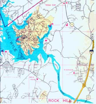
In 1926 the height of the dam was raised and the lake surface expanded from about 5,000 acres to its present 12,455 acres. 6,455acres of which are in South Carolina and 6,000 in North Carolina. The lake has a shoreline of 321 miles and reaches depths of 80 feet impounding 280,000 acre/feet of water. On October 3, 1960 the lake was dedicated to and named for Dr. Walker Gill Wylie.
THE BUSTER BOYD BRIDGE

The Buster Boyd Bridge named for William Monroe 'Buster' Boyd Jr. a south Mecklenburg cotton farmer. Boyd lobbied the Mecklenburg County legislature first for a hard paved road from Charlotte to the Catawba; then for a bridge across the Catawba. He donated his land on the North Carolina side of the Catawba River to the state so the bridge could be built. On January 9, 1923, the Buster Boyd Bridge was opened to automobile traffic between York County, S.C., and Mecklenburg County, N.C. Before the bridge was built, automobile traffic from Rock Hill to Charlotte had to go through Gastonia. The bridge link across the Catawba River cut about 35 miles off that trip.
Building the bridge became a joint venture of the two counties. The original estimated cost of the bridge was $120,000, with Mecklenburg agreeing to pay two-thirds and York County paying the balance. The engineering plans called for a bridge 1,378 feet long in 10 spans. The substructure was to be concrete piers supporting a two-lane wood plank floor covered with asphalt. The estimated time for construction was six months. However, bad weather and unexpected subsoil conditions on the river bottom resulted in an extended construction schedule with increased cost. York County, when faced with the additional costs, refused to pay.
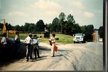
Mecklenburg County completed their hard surface road before the bridge was to open. York County had originally planned a $35,000 sand-clay road to be built with convict labor from Rock Hill to the bridge, but when the bridge was opened only three miles of that road had been completed. The fact that the road on the York County side was virtually impassable did not keep Mecklenburg County from planning a big celebration for August 17, 1923. In July, the general public was told of the plans: The governors and highway commissioners of both states, as well as various officials from both counties were to participate. Community bands and scout bands would furnish the music. Local farmers would provide free barbecue. Cold drink stands and picnic tables would be set up. When the great day came, there were an estimated 12,000 people present. Automobiles lined the road for miles in both directions.
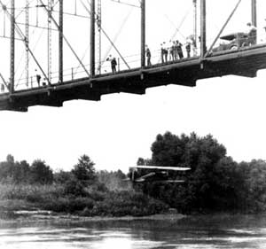
Forty acres on the North Carolina side were cleared for a parking lot. A dry creek bed hillside provided a natural amphitheater for the orderly crowd and the speaker’s stand, all on land that would later be inundated by the dam. North Carolina governor Cameron Morrison, a native of the Charlotte area, having previously won the governor’s office on a platform calling for good roads, again expressed to the crowd how roads would lead to important progress in both states. These Farm-to-Market roads would allow the farmer to bring his products to the consumer thus energize the local economy. Morrison was followed on the podium by a succession of speakers who also extolled good roads as the key to progress. But the crowd, almost all having arrived by automobile, was not concerned about the farmers, highways had become the concern of every traveler, every automobile owner, and their numbers were expanding rapidly. They dreamed of being freed. Freed from decades of battling mud and choking dust. This was an historic event. An event important enough to be recorded by Pathe News for showing in movie theatres across the country.
As the ceremony was closing two young men from Charlotte, P.R. Redfern and B.F. Withers Jr., flying a Curtis biplane, swooped beneath the bridge. The 'trucks of the plane,' according to eyewitnesses, 'tossed up a spray of water as they touched the surface.' Later Capt. Elliott White Springs of Fort Mill, a World War I flying ace and local barnstorming hero, treated the remaining crowd with yet another flight under the bridge.
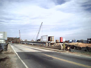
The original Buster Boyd Bridge was struck by a truck and closed to traffic in September 1961. Traffic was again forced to detour through Gastonia. Fortunately, a new bridge had been under construction for some time. Buster Boyd II was opened to traffic the following month October 1961. In the mid 1980s repainting of the bridge was budgeted. In 1987, because of petitions from environmentalists claiming removal of the existing red-lead primer would cause irreparable harm to the lake, painting was delayed. Thus, a new four-lane bridge was designed. The new design estimated to cost $11.2 million was begun in April of 1999 to be completed November 15, 2001. The plan calls for completing the first two lanes of Buster Boyd III to the North of the current bridge over the line of the 1923 structure. When these lanes are opened to traffic, the 1961 bridge will be closed. It will be carefully demolished and disposed of in a way that will not cause any environmental impact to the lake. Then the second two lanes of Buster Boyd Bridge III will be built over that line. This time South Carolina has completed its access road, North Carolina is still working on theirs.
The Buster Boyd Bridge continues to divide the lake into two parts. In the past, many boats have been relegated to the northern or southern sections of the lake because they could not clear under the bridge. In response to appeals from many boat owners on the lake, the North Carolina Department of Transportation agreed to raise the center section clearance by 5ft allowing free passage to many more vessels.
CAMP THUNDERBIRD

Curtis B. Johnson wore a hat to cover his baldness. He wore his hat even when sitting at his desk. He wore a vest, the gold chain from his pocket watch draped through the center buttonhole. He rolled his own Bull-Durham cigarettes, ineptly. Their ash speckled his vest over his adequate stomach. Sleeve garters completed the image of the stereotypical newspaperman, who in 1924, took an apartment in the new Hotel Charlotte and assumed the management of the Charlotte Observer. He came from Tennessee where he owned and operated the Knoxville Sentinel.
Curtis B. Johnson had entered the newspaper business in 1897 as an advertising salesman for the Knoxville Sentinel. He began buying stock in the paper and by 1910 he owned the company. He learned the business well. He knew cost and revenues to the penny. He was a hard taskmaster but was respected as a fair and honest man. He had a reputation for being tightfisted, but privately Johnson helped many people survive the desperate days of the depression.
One day Johnson was searching for a word in the dictionary when the urchin who regularly sold snack-crackers and candy bars in the Observer offices and pressroom approached him. Offhandedly he asked the boy how to spell the word he was seeking. The boy of course did not know, so Johnson showed him how he was using the dictionary to find out. The young boy’s name was Frank Vitta and he became a personal favorite of Johnson. He would occasionally buy the boy lunch or some new clothes. He continued to challenge the boy with somewhat difficult spelling words.
In 1936 Johnson decided to send Frank to a summer camp in the mountains. Johnson was astounded when he returned from the mountains two weeks later tanned and healthy looking. Johnson was so impressed he immediately initiated a program for the underprivileged white boys in the Charlotte area. On May 29, 1937 Duke Power Company transferred ownership of 123 acres just south of the Buster Boyd Bridge, on the western shore of their 'new Catawba pond,' to Curtis B. Johnson who, on January 6, 1938 transferred 119 acres thereof creating the Charlotte Observer Fresh Air Camp, Inc. By 1946 the Camp operation had grown so large that Johnson decided it need professional management. He gave the operational rights to the Charlotte YMCA who operates it as Camp Thunderbird. (Legally the property is still the Charlotte Observer Fresh Air Camp, Inc. owned in trust set up by the Curtis B. Johnson Benevolent Association, Inc.)
In 1941, Johnson purchased seven and eight tenth acres from the camp for $25 an acre giving him personal title to eleven and eight tenth acres on the point next to the camp. He built a large summerhouse for him and his wife. He had a passion for wild ducks and collected many varieties. He clipped their wings so they could not fly away and built a small brick reservoir in the lake to contain them. He built a creek with a waterfall and a little bridge. About one and a quarter mile up the road he put a pump to circulate the water from the reservoir which then gurgled back down into the 'Duck Pond.' Mrs. Johnson reportedly enjoyed the sound of the running water through the open windows on the hot summer nights before air-conditioning.
COMMODORE POINT
On November 30, 1946 Curtis B. Johnson leased the lakefront property to William H. Belk, founder of Belk Stores. On June 13, 1947 in a very complex real estate deal involving a third party, Garments, Inc., the property was sub-divided and deeded to W .H. Belk, Henderson Belk, and Belk Brothers Co. The Belk’s added a pool-house cottage and another building down by the Duck Pond, which they called the Crows Nest Cottage, and set up a family and employee summer-time retreat. John Belk bought a large war-surplus Army Quonset hut and erected it on the site. The Quonset Hut was used for meetings and company parties. Each of the family members had their favorite place, whether it was the main house, the pool house, or down at the duck pond. Company picnics were a regular summer time activity.

During this period of time Henry Belk became fascinated with psychics and psychic phenomena. Henry had toured Europe and had heard of the work of one Peter Hurkis. He asked Doctor Puharich, a renowned psychic of the time, to invite Peter to come to America to be tested at his Round Table Laboratories. Actually, Henry Belk financed most of that project. Henry had also started his own Psychic Research Foundation and had his own reasons for wanting Peter to come to this country. He believed that they could use someone like him to help operate the family’s stores. Like all retail stores they had trouble with shoplifting and dishonesty among their employees. Henry thought someone like Peter Hurkis would be the answer to these problems. Henry asked Puharich and Hurkis to experiment with techniques that could help with these problems as well as with new store locations, advertising, and other uncertainties in the retail business. Henry placed extraordinary confidence in him for both business and personal affairs. Eventually Henry became very disappointed and even bitter.
Belk's disenchantment began when the stores he opened in Miami and Atlanta were not as successful financially as Peter had predicted. However, it was a family tragedy at the river that really caused Henry to proclaim he would never again trust a psychic, for business or personal reasons.
In June of 1957 Henry’s daughter disappeared from the main house where they were vacationing. York County Deputy Sheriffs combed the woods around the area for hours, but were unable to find any trace of the girl. This was the only child of Henry Belk. She was a beautiful little girl and only ten years old. The distraught father still believing in physic powers, late that night called Peter Hurkis who was now living in Miami, Florida. He hoped that through some psychic phenomena Peter could help them locate his daughter. It is reported that Peter, upon receiving the call, thought silently for moment but drew a blank. He told Henry that he would concentrate and call back. As soon as he hung up the phone he saw a clear picture of a girl in six-foot deep water by the boathouse. Peter agonized over the need to call him back and tell him what he had envisioned. He made the call. He told Henry that his daughter had drowned. He told him to look by the boathouse at the third piling on left side and he would find his daughter in six feet of water. It was too much for him.
Belk went directly to that spot and, there by the third piling, he found his daughter’s body exactly in the position described by Peter. Belk was inconsolable at the loss of his only daughter and became very bitter. He never forgave Peter Hurkis. Henry kept asking over and over again, ‘if Peter could see ahead, why couldn't he have told me what was going to happen in time to save my daughter. Why didn't he tell me my daughter was going to drown.’ Henry felt that having spent whole days with Peter and having given him readings about the stores, the business, salesmen and advertising, why couldn't he have told him sooner about his daughter. Belk fired Peter Hurkis and never forgave him.
On May 12, 1960 the Belks closed on the sale of the property to the Marine Development Corporation who named it Commodore Point.
COMMODORE YACHT CLUB
After the drowning of Henry's daughter the Belks lost interest in their riverside retreat and listed the property for sale.
Wilson Lewith, a Charlotte machine shop operator, had a summer place on the East shore of the lake. He used to cruise the lake and wave to his friends and other boat owners. They would lash-up at times and discuss how nice it would be if there was a place on the lake were all the boating enthusiast could get together. So when he heard the Belk property was for sale he visualized it as the ideal place for a Yacht Club. He convinced his friend Maurice Weinstein to join him in the purchase. They made an offer to buy the property and on May 12, 1960 the Belk interests were deeded over to the Marine Development Corporation. Lewith converted the Belk Mansion into a clubhouse and proceeded to organize the Commodore Club. They set up a bar and an epicurean restaurant in the converted mansion and rapidly developed a first class social club. They converted the structure by the Duck Pond into a lunch and snack bar. They organized dances and fish fries. They developed a social calendar unparalleled in these parts. Their membership grew.
The Quonset hut, which John Belk erected, was destroyed by fire before the property was sold. The Commodore Club built a more functional structure on the site. It was a brick building with a wall of windows facing the lake. It was essentially a large open hall with banquet-kitchen facilities. It served as a meeting room, a ballroom, or a dinning room for private parties. It became known as the Regatta Room.
By early 1970, with the project well underway, Lewith and his associates where ready to mail brochures to prospective purchasers. In the course of developing a marketing strategy and advertising material they approached Prentes Designs and Jerry Smith for support. Smith at the time was associated with Sea Pines of Hilton Head development. Smith was impressed with the potential of the Commodore project and recommended that Charles Fraser, the developer of the Sea Pines of Hilton Head project, consider the property for development of the first non-coastal Plantation.
Fraser inspected the property on Lake Wylie, liked what he saw, and immediately began negotiations to buy out the Commodore group and the River Hills Plantation, a Sea Pines Community, was born.
The Sea Pines professionals from Hilton Head reviewed the limited site plan that had been developed by the Commodore group. Hamilton's Ferry was in place and paved. They concurred that the early lot plan along a road to be named Fairway Ridge was appropriate and began selling properties from this plan. The lot at 80 Fairway Ridge purchased by Tom Carr in October 1970, was the first residential lot sold in River Hills. During this time Sea Pines was advising prospective buyers that 'our plans do not include dedicating any land to single family waterfront lots.' Later in a news letter dated 3/10/71 it was stated, 'we have made a decision that one area would be opened up for waterfront lots.'
By April of 1971 the first two homes were under construction: The Smith house on Heritage Drive overlooking the 7th fairway and the pond, and the Yon house on Fairway Ridge. Bobby and Karmene Yon became the first to move in.
The Sea Pines planners began to define their goals for A Way of Life not a subdivision. So while the normal development plans for land usage, utilities, security, curbs and gutters were being made, other planners were working on the amenity requirements: golf, tennis, marina, game room, general store, restaurants. Still others of the Sea Pines entourage were looking for ways to enhance the quality of life in River Hills and to find ways to attract the desired type of residents. Their primary market would be professionals from Charlotte and the surrounding area. They knew that in order to attract this class of people two things would be necessary: First, River Hills residents had to be able to call into the Charlotte area without the inconvenience of long distance dialing and charges. Secondly they would require the Charlotte Observer Metro Edition delivered instead of the rural edition which was (and is) being delivered in the area. In order to provide the gated-community intrinsic to the Hilton Head Plantation concept it would also be crucial to persuade the South Carolina legislature to allow the SC highway #154 to be dedicated for private use. The Sea Pines people knew that little things mean a lot.
Negotiations were begun on these issues immediately. The SC Legislature passed the bill supporting the dedication of highway # 154 in August 1972. Southern Bell announced that as of February 1, 1973 they would open an unprecedented phone exchange allowing interstate dialing to all Charlotte exchanges as well as those in York county as local seven digit numbers without long distance charges. The Charlotte Observer began a special system for the delivery of the Metro edition. Little things we all have come to take for granted.
River Hills Plantation, A Sea Pines Development, a way of life not a sub-division had begun. Let the good times roll.
THE SEA PINES ERA


By April 1971 Sea Pines Development was in control and the development of the infrastructure and the amenities began in earnest. Contracts were awarded in rapid order for a water and sewage disposal system and the paving of Fairway Ridge and Heritage Drive. The Sea Pines Golf professionals examined the golf coarse and designed changes to fairways #2 and #16. They completely redesigned #18. Construction was started on the front-gate guardhouse and a combined golf proshop / property sales building.
The Sea Pines marketing staff also blossomed. Operating out of the old Belk Mansion they developed the theme 'A WAY OF LIFE not a sub-division' and initiated a major advertising campaign. They stressed that River Hills Plantation was 'A 763.0 acre recreation-oriented primary home community'. They held sales parties in the Regatta Room inviting Charlotteans by direct mail to come and bring their friends. Lots were sold, houses were started. They opened the old Commodore Yacht Club swimming pool to all property owners for the summer of 1971. The old Commodore Yacht Club's 'Crows Nest' was made available to residents and property owners for private meetings and parties.
In August of 1971 Sea Pines closed on a $3,490,00 second mortgage with Guardian Mortgage Investors (GMI.) of Jacksonville, FL for the development of the River Club and 'Moore's Landing' marina and tennis complex. The primary mortgage was with First Federal Saving and Loan of Rock Hill.
On June 10, 1972 with a great deal of hype Sea Pines held the Grand Opening of the River Club. All current property owners were invited to come and bring their friends.
In April the plans for the Bluff Villa Townhouse Condominiums were being shown and pre-construction orders were taken.
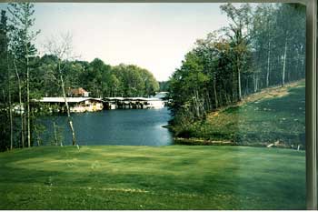
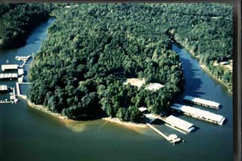
A $1.25 million plan for Moore's Landing was unveiled. It called for the removal of the old Commodore Yacht Club docks on Commodore Point as well as those of Pier 88 the marina Henderson Belk built in the cove below the Bluff Villa site (where the River Hills Marina is today.) Moore's Landing, named for Dr. Moore the previous owner of much of the property in the area, called for the construction of over one hundred and fifty covered boat slips plus a gas dock. (An additional dock with 28 slips was added during the construction phase.) Also included in the plan was a racquet club with seven-lighted clay tennis courts and a pro-shack. Completing the Moore's Landing complex were three buildings: a convenience store, a shower and locker room for boaters, and a Recreation/Club room for community meetings, classes, and general socializing.
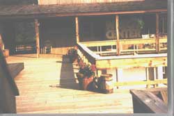
The Moore's Landing complex was completed pretty much as planned. A Convenience Store chain with gasoline retailing experience was brought in to operate the store. Along with the normal merchandise for this class of store they also carried a nice stock of wine, plenty of ice cream, fishing tackle and bait. The store had a covered porch (where the conference room is now) with rocking chairs facing out to the cove. Here one could sit and rock, licking an ice cream cone while watching the boats come and go. Over this porch was a small lunchroom and bar known as the 'Bridge.' Here one could enjoy the view down the cove, while dining on delicatessen type food and imbibing their favorite refreshment.
This complex was opened with a roar. The Plantation Press reported that on June 16th 1973 in response to a direct mail invitation, an estimated 700 people gathered on the decks and wandered the boardwalks of the Moore's Landing to celebrate its Grand Opening. Over 300 pounds of shrimp were piled high on tables lavishly set with turkeys, hams, beef, and bar-b-qued shish kebobs. Every imaginable variety of fresh fruit was available along with cheeses from all over the world. Four open bars were set up in the surrounding area and a combo provided music. A champagne fountain in the center of the deck topped off this most festive occasion.
Lots were selling well. Building permits were being issued, houses were being built. Lot prices were rising. Basic lot prices rose 175% and fairway lots rose by 160% between 1971 and 1972. Bluff Villas were selling well and Phase II was started. . In the mean time plans for medium rise, 3 to 4 story garden apartment type condominiums, like those on Hilton Head, were being discussed for South Point and Commodore Point. River Hills Plantation marketing led the way. It defined the life styles:
'The Villas vs. the patio home vs. the homesite' 'Three separate, distinct, and satisfying ways to live. In one distinctive 884-acre world. In River Hills Plantation, you can choose Bluff Villas, our charming condominiums overlooking Lake Wylie and Moore's Landing Marina/Racquet Club.
Or our patio homes, unique, country-contemporary residences in which a private courtyard replaces the traditional lawn. Or lovely homesites set into pine and hardwood forests. You will find one that is your own place to call home.
But your home is just the beginning of living well. The country world of River Hills is a complete world, carefully and subtly planned to give you a sense of mature, developed community, a special sense of place, that's ready now. Without crowding. And without waiting.
The people who live at River Hills are an interesting lot. We'll never be a rigid, sterile, 'special interest' community. Golfers can pursue their sport on 18 beautiful, championship holes without falling over the tennis and boating and fishing people. They'll be down at Moore's Landing, where the water world of the river and the racquet club complex is big enough for everybody. The River Club and the little lounge atop the general store are quiet oases for unwinding. The recreation center at Moore's Landing lets neighbors get together whenever they like. And River Hills is full of natural wooded nooks and crannies for hiking and picnicking and just unwinding, when the mood strikes.'
River Hills Plantation was becoming ' A way of life not a sub-division.'
In September 1973 Sea Pines abandoned their plans for garden apartment style condominiums at South Point and began construction of patio homes.
In November of 1973 the River Club sponsored a golf tournament which attracted the pro-golfer Tom Weiskopf and the governor of the great state of South Carolina, John West.
In July 1974 Sea Pines announced that the 10 acres between fairway #17 and the tennis courts were sold to Delta Management for the development of 70 condominium town houses. (Later developed into Quayside and Shipmaster with 36 patio homes). Sea Pines was also negotiating for the development of 8 patio homes on the left side of the 18th fairway along Heritage Drive
TROUBLE IN PARADISE
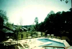
By 1974 stocks were beginning to see the bottoming of the two-year Bear Market which had cost investors 45% of their market value. These financial losses plus the lack of confidence arising from the uncertainties surrounding the resignation of Richard Nixon were taking their toll on the real estate market. The completion of the Bluff Villa’s pool in May 1974 essentially completed Sea Pines’ amenities and infrastructure commitments. Although they had decided to decrease the density of the development they continued with Phase III of the Bluff Villa complex. About a third of these new villas were eventually foreclosed and auctioned by NCNB (Bank of America) in November 1977.
In November 1974 the Plantation Press, the company newsletter circulated by the developer ceased publication. In April of 1975 Trina Nochisaki and friends, resident entrepreneurs published the first issue of the River Hills Press. (All issues of both publications are available for review at the River Hills Community Association offices.)
By now the residents of River Hills were beginning to realize that Sea Pines would not be around forever to plan their lives and entertainment. So some began to get organized to run the Plantation both socially and politically. The HomeOwners Association took over the quarterly billing of property assessments. The Bluff Villas hired a manager. Gene Jester was hired as the first minister of the community church. The congregation of which, in response to a Sea Pines declaration that the Regatta room would be razed, committed to the development of a dual purpose building for church services and community functions. Sea Pines offered to deed the land between the 18th green and the River Club parking lot for that purpose. The church elders originally agreed to that site but requested and obtained the current site before construction was begun in 1976. The congregation held their first services in the new community hall on May 1, 1977.
1974 stocks were beginning to see the bottoming of the two-year Bear Market which had cost investors 45% of their market value. These financial losses plus the lack of confidence arising from the uncertainties surrounding the resignation of Richard Nixon were taking their toll on the real estate market. The completion of the Bluff Villa’s pool in May 1974 essentially completed Sea Pines’ amenities and infrastructure commitments. Although they had decided to decrease the density of the development they continued with Phase III of the Bluff Villa complex. About a third of these new villas were eventually foreclosed and auctioned by NCNB (Bank of America) in November 1977.
In November 1974 the Plantation Press, the company newsletter circulated by the developer ceased publication. In April of 1975 Trina Nochisaki and friends, resident entrepreneurs published the first issue of the River Hills Press. (All issues of both publications are available for review at the River Hills Community Association offices.)
By now the residents of River Hills were beginning to realize that Sea Pines would not be around forever to plan their lives and entertainment. So some began to get organized to run the Plantation both socially and politically. The HomeOwners Association took over the quarterly billing of property assessments. The Bluff Villas hired a manager. Gene Jester was hired as the first minister of the community church. The congregation of which, in response to a Sea Pines declaration that the Regatta room would be razed, committed to the development of a dual purpose building for church services and community functions. Sea Pines offered to deed the land between the 18th green and the River Club parking lot for that purpose. The church elders originally agreed to that site but requested and obtained the current site before construction was begun in 1976. The congregation held their first services in the new community hall on May 1, 1977.

The Lions Club was organized in 1975 and in 1976 initiated their first annual raffle. That year they offered 200 tickets for $60 with a $5,000 guaranteed first prize. The ticket included cocktails and hors d'oeuvre for two at the River Hills Country Club. In 2000 tickets were priced at $100.00 with a $10,000 guarantee. In 1978 they took over the River Hills Plantation telephone directory, which the Women’s Club had published for the two previous years. This project rapidly became and continues to be the Lions largest moneymaker. Staffed by approximately fifty volunteers each year the Directory, which lists only River Hills residents is distributed free to all households in the Plantation. The proceeds from the sale of directory advertising contributes approximately $30,000 of the $70,000 raised for the Lions Charities, which annually contributes to over twenty local benefactors in addition to their gifts to Lions International charities.
In 1975 the River Club members made an offer to buy their club house, the golf facilities, and the tennis complex based on the attained membership of over 300 as set forth in the property buyers guide. This offer set off a long-term negotiation between Sea Pines, their lender - GMI, and at least two factions of club members. Sea Pines had concerns that the membership, divided as it was, would not operate the club in a manner that would attract new buyers to the community. GMI’s investors wanted their money. One group of club members filed suit in order to have the court define the terms of possible options for the continued operation of the property. With the Sea Pines negotiations still unproductive by the end of 1976, the newly formed River Club Advisory Board took their offer directly to GMI, who informed them that Sea Pines had no equity. GMI officials professed a deep desire to sell their interest to the members, but emphasized that they must get an acceptable price or they would be forced to seek a for-profit owner/operator. They made the members their bottom line offer and the members went off to arrange financing and raise the cash necessary to close the deal. They raised $250,000 to cover the closing requirements and initial operating expense. The operational turn over of the club was finalized as of Jan 27, 1978.

In October Sea Pines disbanded the River Hills Plantation Development Company and transferred billing for Country Club and Marina charges to their offices in Hilton Head. They quietly sold Commodore Utilities to Utilities, Inc. The operation of these facilities was continued as Carolina Water Services, Inc., a move that has caused the residents a seemingly endless source of contention.
In March of 1978 the Moore ‘s Landing Marina complex was offered for sale. Acme Oil (Handy Pantry) the operator of the Convenience Store and gas dock refused their first rights. A group of residents were emphatic about their desire to retain control of the Marina and formed the “Committee to Save the Marina.” They did not want to see increased commercialization of the area, which they feared, would reduce residents privacy and security. First Federal S&L, the primary mortgage holder, agreed. A meeting was held in April to educate the residents about what was happening and what the potential results could be. Fund raising was begun. Negotiations were begun with GMI, the secondary mortgagee who by this time was in Chapter 11 bankruptcy proceedings. On April 20, 1978 with no other offers being made the Committee offered GMI $50,000 dollars to take over the second mortgage and control of the property. On May 8 GMI countered with the need for $107,000 plus interest. Still no other bids. On May 9, Dick Lowe, a resident attorney and owner of Harbortowne Marina off highway 274 in Gaston County, offered GMI $100,000. On May 10 the Committee offered $126,000. A matching bid by Lowe was reported accepted on May 19th.
The officers at GMI claimed the Lowe offer was accepted because the Committee’s initial bid of $50,000 did not indicate sincerity nor an appreciation of the value of the property. They were also not convinced that the Committee had the resources necessary to meet their last offer. Litigation to stop the sale was started by the Committee on August 25,1978. GMI delays the sale to Lowe. On August 31 Lowe threatens individual committee members with litigation. GMI states that the bankruptcy court did not clear the sale to Lowe. On September 1 the Committee confirms its offer. Lowe petitions for the dissolution of the Committee. During the next few months the two factions spent a great deal of effort trying to convince their neighbors of their outlook. In circulars and public meetings Lowe explained his plan for boat sales, condos, boatorminium possibilities. He stressed that a volunteer not-for-profit organization would not be able to operate a business that large and that complex. The Committee on the other hand argued the safety and privacy issues. By early October the ownership and operation of the marina by the Committee to Save the Marina gained respect and support. The committee offered Lowe two parcels from the Marina holdings if he would agreed to cease all litigation. Lowe accepted the offer and the Committee took on the task of raising funds. The necessary funds were raised through the sale of non-interest bearing debentures at $500 each to boat owners and other concerned residents. The title was transferred on November 21, 1978.
Seven Years After The Dream: Church is Vital to River Hills
The creation, development, and current existence of the River Hills Community Church is a beautiful story of loving, sharing, devotion and sacrifice that may not be perceived by some of us who view the River Hills Community Church as it exists today. This article will briefly describe some early events in the history of the church and will focus in particular on the physical facility of the River Hills Church and its sanctuary called the “Hall.’
It was in 1973 that seven residents of River Hills planned an Easter Sunrise service to meet the needs of their friends and neighbors. When you realize that less than 50 families were in residence at that time, you can imagine their joyous surprise when over 200 people attended the first religious service held in the community.
This humble beginning gave rise to the thought that perhaps the members of this fledgling community would welcome the opportunity to worship together as friends and neighbors. Avoiding direct sponsorship by any particular denomination, the “Church Committee’ (later to become the first Church Council) elected to form an inter-denominational Community Church where all Christians would feel free to worship. Semi-monthly services were planned with lay leaders guiding the worship service and utilizing guest preachers from the surrounding religious community. This continued until 1974 when a pulpit committee was formed and plans made to hold weekly services. The Reverend Gene Jester was called and installed in May of 1975 and the River Hills Community Church was formally chartered on October 5, 1975.
Launch Building Program
All during this time, church services were held in the old Regatta Room, which was also used for community social events. When Sea Pines announced in 1976 that the Regatta Room would shortly become unavailable for church and other community needs, the River Hills Community Church met with representatives of the River Club, the Property Owners Association and the Mens’ Golf Association to discuss how to jointly solve their mutual problem of acquiring a place to meet. It soon became apparent that the Community Church was the only viable organization willing to take on the responsibility for a building program. Accordingly, the Church Council under the leadership of then Council Chairman John Wilkerson, announced to the community that a building program would be launched by the River Hills Community Church for a church building to serve the community’s religious needs and other community meeting needs when not in conflict with the church. On August 22, 1976 ground was broken for the present church facility and nine months later on May 22, 1977 the River Hills Community Church formally dedicated the new building.
Since that eventful day in May 1977, the church building or sanctuary called the “Hall” has been used practically daily for some church and/or community activity. Aside from religious services and related activities, the church building has also been used more than 350 times by community groups in less than 2 ½ years. Community activities such as Community Association and River Club membership meetings, Boy Scouts, CPR classes, dance, morning exercise classes, American Field Service meetings, Concerned Parents and Teens, Plantation Planters and others to mention a few have all utilized the River Hills Community Church with no charge. This represents a considerable subsidy on the part of the church for community activities when the cost of utilities, janitorial, and general maintenance costs are considered.
The approximate cost of the church building with furnishings was $310,000. Initial pledges for over $150,000 were made by 87 church families and an additional pledge of $8,000 came from 15 others in and outside of River Hills Plantation. New pledges from new church members net out to approximately $25,000 when losses due to transfers, deaths, etc. are accounted for.
These pledges payable over a 3 year period, were designated to repay principal on the mortgage. Payments on the 20 year mortgage are $1,800 per month. This and all operating expenses for the church building amount to approximately $38,000 per year and come from the membership of the River Hills Community Church. Rentals for large social functions this year are estimated to be $1,000 and are based on a “break even” rate to cover utilities and janitorial service.
125 families out of more than 600 resident families have pledged to the building fund. The 210 church member families contribute to the annual maintenance of the church and its ability to serve the community in worship, education, Christian fellowship, and missionary activities.
In addition to the community activities listed earlier, the church building has also been used for several months by the Catholic Church with no fees charged. Discussions initiated by the Catholic Church are now under way to determine how they may share in the maintenance of the building since a continuing relationship seems to be evolving.
The River Hills Community Church is a growing and dynamic group of our friends and neighbors who comprise less than 30% of the families in residence. In addition to serving the spiritual needs of the community, they are in a very real sense subsidizing many activities for the entire community, which utilize the church building. Many thanks are due to the early pioneers and current membership of the River Hills Community church whose vision and devotion are contributing so much to all of us.
THE ERWIN ERA

As of June 1979 all common property in the Plantation was deeded to and placed under the control of the Community Association. This included all of the roads the green spaces the parks. Sea Pines had left the ranch. The take over from Sea Pines required a lot of adjustments the administrative functions that Sea Pines used to provide were now in the hands of three separate organizations: the Community Association, the River Club, and the Marina Club. The River Hills Country Club Board of Directors proposal for an expansion and upgrading of the club house facilities in May 1979 was rejected by the membership. A revised 'not so fancy' plan was proposed and approved in September of that year.
When Sea Pines moved out all of the single-family lots and all the amenities property had been sold. The few remaining unsold parcels scatter throughout the plantation became the property of GMI, the second mortgage holder. These were parcels that Sea Pines had designated for commercial or multi-family development. Their existence as commercial properties had never been disclosed to the residents or shown on any plat map. This fact became known to the residents only after GMI began marketing them to outside investors. Recognizing the opportunity presented by these properties the enterprising young developer who had already purchased the Commodore Point mansion and the Regatta Room properties from Sea Pines, sized the opportunity and with the help of some local investors, purchased all of the remaining Sea Pines (GMI) holdings. Included were:
Ø 1.5 Acres between the 17th Fairway and Heritage Drive zoned multi family.
Ø 4.3 Acre Stable area
Ø 1 Acre Southern end of River Club parking lot
Ø 2 Acres between the River Club and the 18th green
Ø 2 Acres behind the sewage plant
Shortly after acquiring these properties Erwin announced his initial intend for the use of these properties:
Ø The 1.5 acre tract between the 17th fairway and Heritage Drive, which was zoned for multi-family use, will instead be divided into only 6 single family zero lot line plats.
Ø The 2.0 acre plat between the River Club and the 18th green will be leased to the club with the option to buy at the price he paid.
Ø The 1.0 acre site between the cart barn and the rear entrance to the club parking lot will be used for a small inn or guest house. Plans were being developed for an 18-room structure intended primarily for guest or business associates of River Hills residents.
Ø The 2 acres behind the sewage plant will be rented for trailer and boat storage.
Ø The 4.3 acre stable area will continue to be leased to Camp Thunderbird

The launching of these developments thrust Erwin into headlines for the next decade.
The 6 single-family properties along Heritage Drive were developed into patio homes. The Property Owners Association eventually purchased the stables. The Country Club purchased the 2.0 acres in front of the 18thgreen and although both the Community Association and the River Club Boards approved the Inn in principle, Erwin withdrew the plans because of some strong objections. Eventually this land was also sold to the Club.
Erwin formed the Commodore Point Investors to renovate the old Belk Mansion originally built by Curtis Johnson. Erwin, with this group, negotiated a deal with the YMCA Camp Thunderbird trustees who traded the west side of the peninsula and the road for the Regatta Room and other considerations. The property on the right side of the road was divided into mostly single family residence and despite soaring double-digit interest rates and threatening recession the area was rapidly built out. Commodore Point Road was given to the Community Association for maintenance in return for the annexation of the properties thereby providing Association assessments. The old Duck Pond was converted into boat landings for the exclusive use of Commodore Point residents.
When Erwin learned that a three-story office building was being planned for a one-acre tract across from the new church he decided there must be a better use for this space. With a couple of local investors he acquired the property. He planned and proceeded to develop a park-like burial ground
In June of 1979 Erwin announced that he had reached an agreement with Harris-Teeter Food Chain and Revco Drugs to participate as anchors for his proposed Lake Wylie Plaza. Erwin's plans were to develop the 10 acres across from the front entrance with the investors who owned the property. In June of 1980 Erwin broke ground for the development of the Lake Wylie Plaza. The initial tenants would be Harris-Teeter Groceries, Jac-Lyn's Hallmark Store, The Old World Deli, and Revco drugs. The Bank of Fort Mill and First Federal Savings and Loan of Rock Hill would join them soon after. Subsequently the Bank of Fort Mill became part of the South Carolina National Bank, then the North Carolina National Bank and now the Bank of America. First Federal became First Union and is now part of the new Wachovia. Harris-Teeter closed their doors in favor of their new store at the intersection of highway 49 and 160. Revco became CVS and moved to a new stand-alone store across from the back gate.
By the end of 1979 Erwin had become a prime mover in the area. His efforts were instrumental in forming Lake Wylie Chamber of Commerce. He was elected as its first president.
In January 1981 Erwin completed negotiations with Dr. Moore's widow for the purchase of her remaining tract of land in the corner of Marina Road and the Parking lot. A tract that the Country Club had unsuccessfully sought to acquire for additional tennis courts. Erwin announced his intent to build a group of one-bedroom condominiums on the property. After considering some negative public comments Erwin again succumbed to the wishes of the community and reduced the total number of units allowing the inclusion of two bedroom units. A groundbreaking ceremony for the development of Moore's Landing Condominiums was held in June of that year.